Categories
Lab Exercises

2. Immersive User Experience (UX) and Augmented Reality (AR)

What is AR?

Augmented reality is used by apps like Instagram and Snapchat. AR design is used in the editing of photos and selfies, the superimposition of digital costumes, the application of makeup, the alteration of the face, and the modification of voice (Joseph Downs, Justinmind, 29 August 2019).

Figure 1 : But it was the Pokémon Go app (Pokemon Go, 20 December 2017.) that really opened our eyes to how AR could impact the physical world. When this app first came out in 2016, up to 45 million people downloaded it in an attempt to find virtual Pokémon in the real world (Joseph Downs, Justinmind, 29 August 2019).

Still, there are other factors besides social benefits that might make users happy. People can feel enthusiastic about their next purchase by using the IKEA Place app, which allows them to preview how furniture would look in their house. They are able to save money and time as well. In short, augmented reality (AR) improves or augments your present world in some way, as the name would imply (Joseph Downs, Justinmind, 29 August 2019).

Advantages of AR

One of the most appealing characteristics of AR is its use of real-world surroundings. This means that, unlike virtual reality, designers do not have to construct a totally new environment from scratch. Instead, the context of the user can be exploited to create an augmented experience in which virtual items become a part of the real environment (Ramotion, 9 January 2023).

Limitations of AR

The user experience is another drawback of AR. AR can provide incredible and fascinating experiences, but it can also cause users to face eye strain, motion sickness, privacy problems, and social embarrassment. These difficulties have the potential to impair customer enjoyment, comfort, and trust in AR technology (Augmented Reality, Linkedin, n.d).

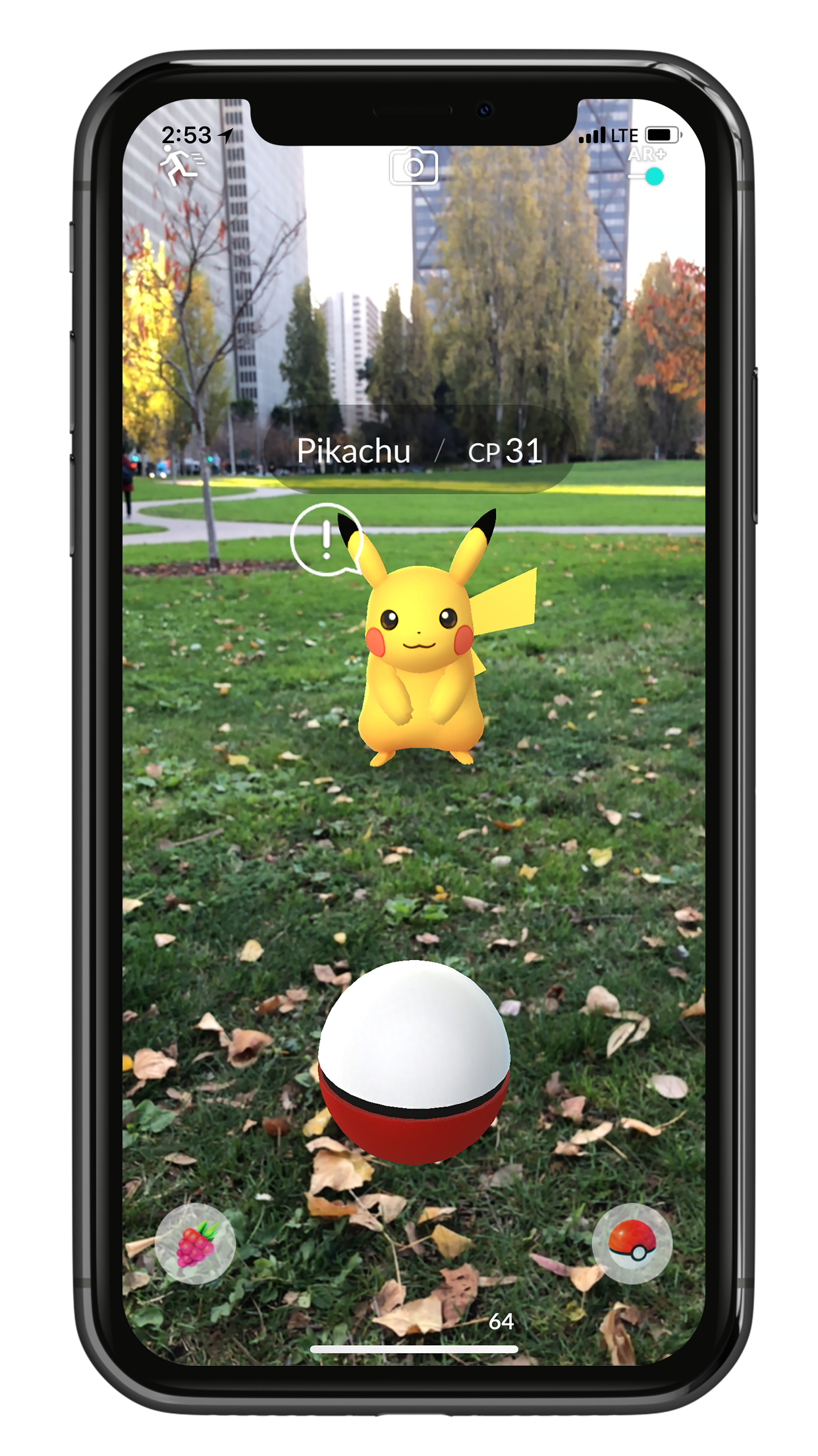
Experimentations with AR

Figure 2 : Adding Zappworks assets to Unity is the first step in creating AR.

Summary

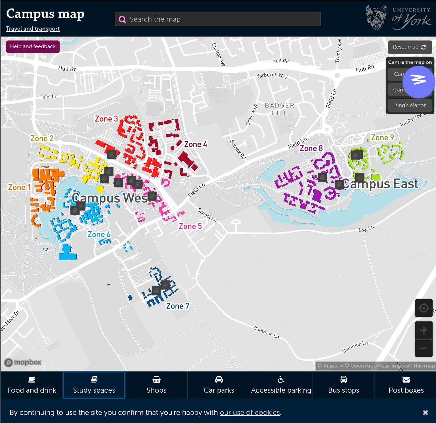
Following some testing and analysis, the decision was reached to use AR if the projected project is compatible with it. AR strikes a solid balance between reality and virtuality, however some accessibility advancements might be made even further. This media is perfect for bringing historical landmarks to life or for navigating by providing realistic representations of streets.

References

Augmented Reality, Linkedin, n.d. How can you overcome the limitations of Augmented Reality technology? [Online] (Updated in 19 September 2023) Available at : https://www.linkedin.com/advice/0/how-can-you-overcome-limitations-augmented-reality [Accessed in 27 October 2023]

Joseph Downs, Justinmind, 29 August 2019. 18 AR, MR and VR design principles [Online] (n.d.) Available at : https://www.justinmind.com/blog/vr-design/ [Accessed in 25 October 2023]

Pokemon Go, 20 December 2017. AR+ is now available in Pokémon GO! [Online] (n.d.) Available at : https://pokemongolive.com/post/arplus/ [Accessed in 25 October 2023]

Ramotion, 9 January 2023. AR in UX design: From Design Principles to Best Practices [Online] (Updated in 22 August 2023) Available at : https://www.ramotion.com/blog/ar-in-ux-design/ [Accessed in 25 October 2023]

Categories
Lab Exercises

1. Prototyping Your Immersive Experience

What is VR?

VR is, as the name suggests, a virtual environment into which the user can enter and experience as their own reality. There has been a lot of experimenting in VR design in the previous several years. Despite the fact that it has been there since the 1960s, VR design has only recently risen to the fore (Joseph Downs, Justinmind, 29 August 2019).

Figure 1 : Devices like Google Cardboard, Facebook’s Oculus Rift, and Samsung’s Gear VR were the first steps towards a growing technology. These devices enable users to have immersive, 3D experiences by downloading a VR optimised app and connecting their phone (Joseph Downs, Justinmind, 29 August 2019).

Advantages of 360 VR User Experience

Users can have an extremely engaging and interactive experience with VR. Virtual reality has many applications and uses, including entertainment and education. To keep people interested and pleased with their entire experience, designers can produce extremely immersive experiences (Ramotion, 16 January 2023).

Limitations of 360 VR User Experience

When incorporating 360-degree video, keep in mind the possibility of viewer weariness and confusion. The format’s immersive aspect can be both a strength and a weakness, since some viewers may find the experience overpowering or confusing, especially when viewed with a VR headset. This can result in a poor user experience and discourage some visitors from engaging with your material (Marcin Frackiewicz, TS2, 10 July 2023).

360 3D Content Using Maya – Week 1

Figure 2 : Rendering started after attempting to set up the animation to be viewed in VR.
Figure 3 : Rendered scene using 360 VR Camera.

WebVR – Week 2

Figure 4 : To begin exploring WebVR (https://framevr.io/ktr-nvp-tyo) log in to FrameVR and select a background that best suits your needs or the task at hand. You can select different assets, ranging from 2D to 3D to video, by selecting the + icon.

Summary

It was decided to use Frame VR for personal projects and further development after testing them out. Frame VR enables the creation of the virtual reality world beyond the headset, which is why this choice was picked. Multiple people can access the area and more media can be imported into it. With simply the website connection, the user can access the VR scene, making the smartphone an additional VR headset which could solve with fatique and VR sickness.

References

Joseph Downs, Justinmind, 29 August 2019. 18 AR, MR and VR design principles [Online] (n.d.) Available at : https://www.justinmind.com/blog/vr-design/ [Accessed in 15 October 2023]

Ramotion, 16 January 2023. VR in UX Design: Basic Guidelines for a Better Experience [Online] (Updated in 22 August 2023) Available at : https://www.ramotion.com/blog/vr-in-ux-design/ [Accessed in 15 October 2023]

Marcin Frackiewicz, TS2, 10 July 2023. The Pros and Cons of 360-Degree Video for Businesses [Online] (n.d.) Available at : https://ts2.space/en/the-pros-and-cons-of-360-degree-video-for-businesses/#google_vignette&gsc.tab=0 [Accessed in 17 October 2023]

Categories
Proporsal

Post 5 : Project Planning

Project plans are essential because they provide a shared vision of what the project hopes to achieve. This shared understanding motivates the team to work together to meet the project’s objectives and deliver exceptional outcomes (Kelechi Udoagwu, 2 May 2022).

Project plans define the roles and responsibilities of each project team member and stakeholder. They also organise the project’s work from beginning to end, preventing unnecessary jobs from crowding out vital ones. Throughout the project, project planning can serve as an effective communication tool for the team (Kelechi Udoagwu, 2 May 2022).

Project Planning of Wayfinding

It was crucial to consider early in the project planning process how the earlier research would be used to create the app or web-based solution. My goal is to use augmented reality (AR), which is turning into a helpful tool and immersive technologies that provide users a realistic experience, to assist users, including visitors and international students, in navigating the university campus. Since this project won’t be finished until the beginning of May, planning ahead is essential for maintaining focus and ensuring that all necessary steps were taken to address the problems individuals are having.

Logo Design

Maintaining consistency with the University of Hull’s colour scheme and utilising the symbols used in all of their marketing and visual language are crucial when designing a logo.

Figure 1 : Experimenting with and researching various logo design ideas and potential ways to demonstrate development in the future.

Visual Design

When designing the visual, it’s crucial to take into account what has already been done and figure out how to make it work differently because the AR The need with Google Live Maps was to hold the phone forward as though you were filming, drawing attention from onlookers. To address this issue, the application ought to adjust to the surface like augmented reality apps do. This indicates that the symbols will follow the user’s phone pointer, which ever direction they aim it. To avoid confusing users, this tool will also make use of universal symbols.

Figure 2 : Making a basic sketch of the prospective app design and how it might look, but more work and consideration of accessibility issues is required.

Presentation

Summary

After completing the planning work for the possible app, it began the development process, which will be continued into the development stage. The planning timetable will assist in staying on track with the process.

References

Kelechi Udoagwu, 2 May 2022. Project Planning Essential Elements (With Infographic) [Online] (n.d.) Available at : https://www.wrike.com/blog/essential-elements-perfect-project-plan-infographic/ [Accessed in 02 Nvember 2023]

Categories
Proporsal

Post 4 : Summary And Potential Solutions

Challenges

There are numerous restrictions and difficulties when it comes to currently available apps and web bases during the research process. From errors to poor design, which makes consumers less inclined to utilise it and especially individuals who are going overseas or coming to the UK as international students in this field of technology.

Figure 1 : My own experience has shown me that it’s not always easy to find your way around in a new place, and that people with accents often find it difficult to communicate verbally because they can’t pronounce certain letters or read the map due to language barrier. So by having visual app would extremely ease the daily experiance (University of Hull, n.d).

Solutions

By developing an augmented reality app/web, users would be able to share their experience with their peers by sharing the link. This app/web would also aid with navigation, reducing the need for verbal communication in a country they intend to visit through the use of visual communication symbols such as instructions and universal symbols. These symbols are frequently used to represent shops or food retails. Google Live Maps offers an alternative, however it’s a little rough and doesn’t solve the challenges that tourists face when travelling. Augmented reality is increasingly relevant in the tourism business as an added experience with less resources needed, such as paper maps.

Visual Language

Compared to other theories, the brain activation pattern discovered in this study provides substantial support for the multisensory learning idea. Furthermore, the findings emphasise how crucial it is to learn vocabulary in other languages through enrichment, especially when it comes to self-performed gestures (Katja M. Mayer, Izzet B. Yildiz, Manuela Macedonia and Katharina von Kriegstein 2015).

University Of Hull

University of Hull was chosen as the testing location because, on my first visit, I found it difficult to navigate the campus with a paper map because it wasn’t up to date. It didn’t help that I had looked up the location of the major buildings on my Google Map before leaving. Since I still have trouble following directions, I just follow my classmates whenever we have to go anywhere as a class. Considering my own challenges, I believe that developing a wayfinder would help all university community members, but particularly international students.

Summary

Considering all of the difficulties people are having, a solution like AR campus wayfinder will help all users and offer capabilities that other options do not.

References

Katja M. Mayer, Izzet B. Yildiz, Manuela Macedonia and Katharina von Kriegstein 2015 Visual and Motor Cortices differentially support the translation of foreign language word. Current Biology, Volume 25, Issue 4, Pages 530-535.

University of Hull, n.d. Campus Map [Online] (n.d.) Available at : https://www.hull.ac.uk/editor-assets/docs/campus-map.pdf [Accessed in 30 October 2023]

Categories
Proporsal

Post 3 : Case Studies

Google Maps AR

Google Maps AR, also known as Live View, is intended to assist you navigate while walking by using augmented reality. What does this imply? Rather of just displaying a map, it uses the camera on the back of the phone to determine where you are and directions as details on the display.

Figure 1 : AI recognises what you see, while GPS helps you locate yourself on a map. Finally, Google Maps Live View alleviates the difficulty of not knowing which way to walk because the AR can point you in the appropriate direction so you’re on the right track (Chris Hall, Pocket-link, n.d).

Google Maps AR Limitations

Figure 2 : However, Google Maps Live AR has several restrictions and flaws that a user identified and decided to share his experience with (Bibhash Biswas, Medium, 22 April 2019).
Figure 3: According to his blog, even with a beautifully designed UI and interactivity, the software was slow and misleading because it couldn’t precisely locate the door. He further claims that the app is not adaptive to its surroundings and requires a fixed posture to function (Bibhash Biswas, Medium, 22 April 2019).

There aren’t many AR wayfinding apps at the moment because the industrial sector is just beginning to use AR, which may be used with smart glasses in the future. Nonetheless, the majority of universities use a static campus map that can be challenging to use.

Different University Campus Maps

Figure 4 : As you can see, the University of York lacks interaction, and due to its huge size, they have attempted to provide navigation directions, but it is still difficult to navigate due to not knowing where the entrance is or the quickest way to get there (University of York, n.d).

Summary

Even though the concept is reliable and has a lot of potential going forward, it was found that the wayfinding alternatives available now are still inaccurate after looking over the case studies. Thus, when developing an augmented reality wayfinder, the user should come first, with symbols that appear on the road and the ability to produce a realistic map.

References

Bibhash Biswas, Medium, 22 April 2019. Navigation in Augmented Reality from Google Maps [Online] (n.d.) Available at : https://medium.com/swlh/the-new-google-maps-in-ar-587285a5d523 [Accessed in 28 October 2023].

Chris Hall, Pocket-link, n.d. What is Google Maps AR navigation and Live View and how do you use it? [Online] (Updated in 17 September 2023) Avaliable at : https://www.pocket-lint.com/what-is-google-maps-ar-navigation-live-view/ [Accessed in 28 October 2023].

University of York, n.d. Campus Map [Online] (n.d.) Avaliable at : https://www.york.ac.uk/map/ [Accessed in 30 October 2023]

Categories
Proporsal

Post 2 : History of Wayfinding and Symbols

Wayfinding is the process of navigating through a building, environment, or location. Wayfinding consists of the actions you take to get to your goal, including choosing the optimal route, recognising your destination, and returning to the beginning point, all while using clear and logical signs, pictures, and symbols to help you remember your route (FastSigns, n.d).

Figure 1 : More than 3,500 years ago, in the days of ancient labyrinths and mazes, navigation had its beginnings. Architect Kevin Lynch coined the phrase “wayfinding” in 1960 to refer to the functions of street numbers, maps, directional signs, and other items in urban areas (Curtis Standley, purple, 11 March 2020).

These symbols were used to assist people in navigating to landmarks, locations, and spaces in today’s environment, wayfinding and directional aids and technologies offer orientation and location awareness (Curtis Standley, purple, 11 March 2020).

Wayfing in Day-to-Day Life

Compared to the rest of our history, the past 50 years have seen enormous progress and improvements, primarily because to the unstoppable speed of economic expansion together with advances in science, technology, and even psychology (Curtis Standley, purple, 11 March 2020).

Figure 2 : In our daily lives, we encounter more and more complicated structures, all of which call for appropriate navigation signage, if not outright digital wayfinding solutions, so purple come up with potential way to help people (Curtis Standley, purple, 11 March 2020).

The creation of the mentioned things is also due to the fact that our world is getting more and more globalised, necessitating the employment of user-friendly wayfinding designs, which has led to the development of a common language (Curtis Standley, purple, 11 March 2020).

For instance, one in four persons in the US has a disability that could make getting about your facility more challenging. Furthermore, navigation can assist employees who work in intricate and dynamic situations in addition to tourists (Curtis Standley, purple, 11 March 2020).

Future of Wayfinding

Digital signs and wayfinding systems have become more widely known, but as technology advances, our ability to navigate both interior and outdoor spaces will probably also change. You may make it easier for guests to navigate your venue by installing digital navigation (Curtis Standley, purple, 11 March 2020).

Summary

Following extensive research on wayfinding and an examination of the available wayfinding solutions, the decision was taken to maintain the same symbol system since it is reliable and consistent with all other apps. Even if navigation has progressed to this point, there is still room for improvement with the aid of advancing technology.

References

Curtis Standley, purple, 11 March 2020. The History of Wayfinding [Online] (Updated in 20 October 2023) Available at : https://purple.ai/blogs/the-history-of-wayfinding/ [Accessed in 29 October 2023].

FastSigns, n.d. Wayfinding Signage [Online] (n.d.) Available at : https://www.fastsigns.co.uk/faq/wayfinding-signage/

[Accessed in 29 October 2023].

Categories
Proporsal

Post 1 : Introduction

Verbal communication will become a barrier in the world of travel and tourism as different countries prioritise their narrative language as part of their cultural etnicity. Most European countries utilise English as their primary communication language, which should reduce the speech barrier. English language learnt in school lacks vocal communication, thus if a person learns the language in school visits England, she or he must relearn the language because the country uses slang in most parts. As a result, it remains a barrier for any person who want to travel or stay in England.T

These kinds of issues were addressed in 2000’s by the Google ecosystem, which made language barriers easier by offering services like Google Translate and Maps, which have grown to be the most frequently used apps since you use them whenever you want to travel or locate a location on a map. To translate the instructions at any time, simply select Translate although the tools still need further improvement.

Google Translate

Figure 1 : As you can see, when you sign with your Google account, Google Translate adapts to the person’s narrative language and most of the text was translated although not everything or translation was slightly incorrect (Google Translate, n.d).

Google Maps

Figure 2 : When creating areas, signage, and the navigation and wayfinding system, there are several typical mistakes made in signage design. Examples include incorrect design, grouping, and particularly failing to take into account all potential consumers (Google Maps, 2023).

Visual Language

To address these issues, a viable solution would be to use visual language, which allows for faster communication and enhances vocabulary by the brain remembering the symbols, which aids in remembering the new term. The prospective visual language app and web tool should be accurate and allow for a smooth transition. This method will help alleviate the worry associated with becoming lost in a strange location.

Summary

With these issues in mind, a potential solution will be developed to improve the user experience and fix the challenges we are now experiencing. Inconsistency, translation errors, and accuracy are examples. By developing a new tool that makes extensive use of visual language and addresses all of the navigational issues that users face on a daily basis. Also, when people desire to travel overseas or enter the UK for the first time.

References

Google Maps, n.d. University of Hull [Online] (2023) Available at : https://www.google.com/maps/@53.7725549,-0.3666088,16z [Accessed in 29 October 2023]

Google Translate, n.d. University of Hull [Online] (n.d.) Available at : https://translate.google.com/?hl=lt&sl=en&tl=lt&op=images [Acccessed in 29 October 2023]